Papua New Guinea: An Introduction
New Guinea is the second largest island in the world, just after Greenland. It is located in the southern hemisphere and has a land area of 785,753 km2. The current population of the island of New Guinea is about eleven million.
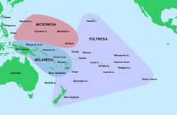
It is considered by some to be the easternmost part of the Malay Archipelago, others include it as part of Melanesia, and it seems to fit more in culturally with Melanesia than it does with the rest of the Malay Archipelago. New Guinea is divided politically into two countries: PNG and Indonesia. (map from 1884). Papua New Guinea occupies the eastern half of the island. The Indonesian provinces, Papua and West Papua, occupy the other half of the island.
The island of New Guinea has been known by many names throughout history. Keeping up with all the names requires a scorecard. among them Papua, Irian, and New Guinea. The last is the name that has stuck in current times. It was originally called this by a Spanish explorer, Yñigo Ortiz de Retez , in 1545 because he considered the people as being similar to the natives of the Guinea region of Africa. Indonesians began to refer to the island and the Indonesian half of the island as Irian; they later changed it to Papua in 2001.
Physical Geography and Wildlife
New Guinea is an incredibly diverse island ecologically. The island contains many of the world's ecosystem types: a stretch of mountains that run from east to west and are perhaps the most dominant feature of the island, alpine tundra, rainforest, mangroves, lake and rivers, and some of the richest coral reefs on the planet. The lowlands extend for hundreds of miles on both the north and 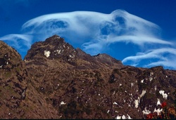 south of the island and include lowland rainforests, some of the largest stretches of mangroves in the world, savana grasslands and the Lorentz National Park that is a UNESCO World Heritage Site. The Sepik and the Fly on the PNG side of New Guinea are two of the largest rivers on the island. New Guinea also has valuable natural resources like gold, silver, copper, natural gas and oil. Some of the highest mountains are Puncak Jaya and Puncak Mandala, the two highest mountains on the Indonesian side of the island. Puncak Jaya is the highest mountain on the island at 4,884 meters. Mount Wilhelm at 4509 meters is the highest mountain on the PNG side of the island.
New Guinea is on the same tectonic plate as Australia and back during the Pleistocene and the last glacial age about 18,000 years BP, New Guinea and Australia were known as the continent of Sahul with a land connection. This was important for the spread of Homo sapiens throughout the area as they arrived out of Africa.
While New Guinea has less than one half of one percent of the planet's surface, it has between 5 and 10 percent of Earth's total species. Many of these are endemic to New Guinea, and it is thought that there are still thousands of unknown species still living 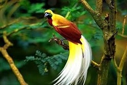 on the island. In fact, between 1998 and 2008, over 1,000 new species of birds, fish, mammals, reptiles, plants, amphibians and invertebrates were identified. A sampling of the biodiversity includes: 284 species of malls (195 endemic), 578 species of breeding birds (324 endemic), 282 species of frogs, 1,200 species of fish and 600 species of reef-building coral (75% of the world's total).
Prehistory
To learn about the prehistory of New Guinea, please see the section on Papua and West Papua.
History
Europeans began arriving in New Guinea in the 16th century, but before they arrived, Austronesians made their way there around 3,500 years ago. There is evidence that the Sriwijaya (centered on Sumatra from 7th to 14th century) and Majapahit (centered in Java from 13th to 16th century) kingdoms did some trading with coastal populations in Papua and may have taken slaves as well. It seems that they made their way to West Papua, whether they made it as far as what is now PNG is unclear.
Between the 13th and 17th centuries, Polynesians arrived and set up settlements on some of the unoccupied islands off the coast of New Guinea including the Trobriands in PNG and some of the Solomon Islands.
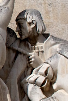 In 1512 Portuguese sailor Antonio d'Abreu sighted the coast, but did not land. In 1526 de Meneses arrived at Waigeo Island in West Papua by accident (he was blown of course on his way to Ternate). He named the island Ilhas dos Papuas meaning roughly the island of the frizzy haired. In 1528, the conquistador, Hernan Cortez, sent Alvaro de Saavreda out to search for the "island of gold." He was also to relieve the Spanish outpost on Tidore which was under siege by the Portugese. He spent a month there with the "naked black people" and made plans to return but never did. Cortez again sent another ship out to find the island of gold, but this voyage was a disaster when the crew mutinied and killed the captain. The ship was abandoned in Cenderawasih Bay. Seven survivors were captured and made slaves by the local population. As I mentioned earlier, Ortiz de Retez sailed along the northern coast and claimed Papua for the Spanish Crown and gave it the name Nueva Guinea. Despite claiming the land for Spain, they never proved to be a player in the colonial games involving Papua. No gold was found and the Spanish essentially gave up although they kept claim to New Guinea only later to give up the claim under the treaty of Utrecht in 1714 to the Dutch and English.
In 1606 Luiz Vaz de Torres sailed along the southern coast from Milne Bay to the Gulf of Papua. He sailed through the straight that now bears his name, but reports of his adventures had been suppressed, although rumors of his journeys did exist and the passage did show up on a few charts. In 1623, the Dutch explorer Jan Carstensz reported that he sighted snowcapped mountains but no one believed him.
The Dutch later effectively made a claim (1660) on New Guinea due to their colonial relationship with the Sultanate of Tidore. But again, outposts were never made and the Dutch interest in the islands was limited to trading with coastal populations and serving as a stopgap for any European countries wishing to interfere with the Dutch monopoly on the spice trade. So, Papua had no spices and no gold (none that was apparent), so it lost much of its interests to the Europeans. But it remained a place with valuable trade goods for the Javanese, Bugis, Bandanese and Seramese.
Valuable trade items included massoi bark - valued for its ability to cure a number of illnesses including venereal disease - nutmeg (low grade nutmeg), trepang (dried sea cucumbers, tortoise shells, pearls, bird of paradise skins and slaves.
The French explorer Bougainville was here in 1768 and named the island of Bougainville for himself. A ten year civil war (1988-1998) cost thousands of lives and resulted in autonomy for Bougainville. Bougainville is now an autonomous region of PNG.
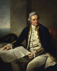 Captain Cook was here in 1770. He was interested in seeing if New Guinea was joined to the Australian mainland. A few of Cook's crew landed on the southwest coast of New Guinea but were afraid to venture to far inland and thus wandered down the coast a bit. Some local residents appeared and threatened the crew who fired upon them. They retreated but came back with a larger group of men who chased off the crew with an exploding white powder.
Thomas Forrest showed up in West Papua in 1774 on orders from the British East India Company looking for spices in places not controlled by the Dutch. Forrest spoke Malay fluently, had excellent relationship with the locals partly because of that and he was also known for his antics with a flute that he took everywhere with him which led to his name among the residents of Raja Ampat of the Mad Captain. Forrest noted in a book that he wrote about his voyages that the residents of the small island in Raja Ampat were of two types: Malays who he called Moors of copper color with long hair and mopheaded Papuas.
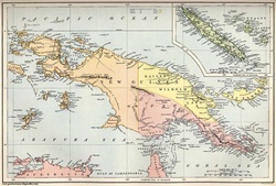 The British made several attempts at settling on the island, but they all failed and by 1824 they agreed with the Dutch that the west side of the island would be part of the Dutch East Indies. German missionaries were active on the island beginning in the mid-1800s. But the Dutch really didn't do much in terms of development.
So, the Dutch had the western part of New Guinea, but the land on the east side of the island was still unclaimed by any European powers. Britain took care of that in 1883 when the British colony of Queensland annexed southeastern New Guinea. The government back in the UK nixed the deal but then claimed the same territory the next year. The Germans claimed northeastern New Guinea called Kaiser-Wilhelmsland and that took up the island for the Europeans. Following this Germany and Britain squabbled over control of islands to the east.
So, with New Guinea now having been claimed by three European powers by the start of the 20th century lets focus on the eastern side of the island that eventually becomes the nation of PNG.
Germany only lasted a relatively short time in New Guinea. At the end of World War I, Germany's territory in New Guinea was given to Australia and was name the Territories of Papua and New Guinea (until 1942). It gained independence in 1975 and became Papua New Guinea. PNG has four regions: Papua, Highlands, Momase, and Islands (inlcueds Manus, West and East New Britain, New Ireland, Bouganville.
In 1905-6, the British transferred the administration of southeast New Guinea to Australia, which renamed the area "Territory of Papua". In 1920 the former territory that was German New Guinea became the Territory of New Guinea and was administered by Australia. The non-Dutch side of the island became known as The Territories of Papua and New Guinea and remained so until February 1942.
So, there was copra, rubber, coffee and cocoa to keep Australia interested enough to make at least minor developments of the island. And then gold was discovered in the 1920s and explorers and miners began to move into the interior. (Australia had patrol officers who kept track of happenings and served as a reminder that a foreigner power was in control of the region.) Let's take a short look at the video called First Contact.
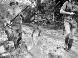 By 1942 the island was split into two parts: one side Dutch, the other Australian. Then things changed radically with the start of WWII. The Japanese occupied Rabaul in January 1942, and they attempted to take Port Moresby that was the last Australian stronghold on the island. They battled the Australians on the Kodoka Track and additionally tried to take Milne Bay. They were repulsed after heavy fighting with Australian troops. This was a major setback for the Japanese forces. However, they occupied many of the smaller islands around New Guinea as well as having a foothold on the Dutch side of the island, especially on the island of Biak where the Americans eventually prevailed and moved the Japanese off the island.
As already noted, Papua became important for the West during WWII. The Japanese occupied what is now Jayapura as well as a number of surrounding islands and most especially the island of Biak and as far south as Timika.
The Dutch and Australians regained control of their colonial possessions once the war was over, although for the Dutch, they were involved in the Indonesian Revolution that took place on the islands to the west of New Guinea. The Dutch eventually left in 1963 long after they had admitted defeat and the Indonesians gained their independence. The Australian side of the island stayed under Australian control until 1975 when the Papuans gained full independence from Australia.
Here's a timeline to help keep this busy history in focus.
- 65.000 - 40000 YBP Homo sapiens arrive
- 3,500 YBP Austronesians arrive from southern China/ Taiwan
- 1512 Portuguese sailor Antonio d'Abreu sights the island
- 1526 de Meneses arrived at Waigeo Island in West Papua
- In 1528, the conquistador, Hernan Cortez, sent Alvaro de Saavreda out to search for the "island of gold."
- 1606 Luiz Vaz de Torres sailed along the southern coast from Milne Bay to the Gulf of Papua.
- 1623, the Dutch explorer Jan Carstensz reported that he sighted snowcapped mountains but no one believed him.
- 1660 The Dutch later effectively made a claim on New Guinea due to their colonial relationship with the Sultanate of Tidore.
- 1768 The French explorer Bougainville was here and named the island of Bougainville for himself.
- 1770 Captain Cook arrived
- 1774 Thomas Forrest showed up in West Papua on orders from the British East India Company looking for spices in places not controlled by the Dutch.
- 1824 British agreed with the Dutch that the west side of the island would be part of the Dutch East Indies
- 1883 The British colony of Queensland annexed southeastern New Guinea.
- 1883 Germans claimed northeastern New Guinea called Kaiser-Wilhelmsland
- 1918 Germany's territory in New Guinea was given to Australia and was name the Territories of Papua and New Guinea (until 1942).
- 1920s gold was discovered and explorers and miners began to move into the interior.
- 1942 the island was split into two parts: one side Dutch, the other Australian.
- 1942 Japanese occupied Rabaul in January
- 1945 The Dutch and Australians took over once the war was finished,
- 1963 Dutch eventually left New Guinea. Indonesia controls the west side of New Guinea
- 1975 PNG becomes an independent country.
OK, so we have an overview of the prehistory/history of the island of Papua New Guinea. New Guinea's resources were just beginning to be realized at the start of the 20th Century: Timber, gold, copper, fish. This country has enormous potential but colonialism, globalization, geography, corruption and ethnicity have worked together to stymie attempts to create a country where resources are put to the use of the betterment of the people.
Over the coming weeks, we'll take a look at some of the people and cultures of Papua New Guinea. Thanks for stopping by.

